Forgotten Path of Route 66 in the Cajon Pass
There is a forgotten road that passes through California’s Cajon Pass that was originally a wagon toll road built in 1861 and, later, was used by many people that also traveled early Route 66. Today, there are no signs pointing out this historic road or its connection to the Mother Road, but you’ll see evidence of where it once existed.


This virtual tour focuses on a historical road that used to run through the Cajon Pass. Although this road was never used as an alignment of Route 66, it was used by Route 66 travelers occasionally as a shortcut. The road is steep and narrow which certainly seemed hazardous to early automobile travelers and adventurous to others. Unlike old segments of Route 66 in the upper Cajon Pass, sections of this old road can still be traveled on today.
The Road
Our trip begins at the historic Summit Inn, located at the Cajon Summit where I-15 and Route 66 crests the highpoint of the San Bernardino Mountains. It ends next to the truck scales located halfway through the Cajon Pass along I-15. It can be traveled in either direction, however since it is on a rough dirt road, it might be easier to travel downhill.
Half of the trip is on an improved dirt road and the other half is on pavement (highway 138). Although most of the dirt road is maintained by the Forestry Service, it is still subject to deep ruts and bumps that make it difficult for normal vehicles with limited clearance to negotiate. However, we’ve seen plenty of sedans on this road.
Nevertheless, we strongly recommend to only travel on this road with a high-clearance vehicle, such as a truck or SUV. 4WD is not needed, unless you are going up hill and the road is in bad condition.
Summit Inn
As mentioned, our trip starts at the historic Summit Inn. It can be accessed from the Oak Hills Road exit of I-15.
Summit Inn opened in 1952. Its current owner has owned it since 1966. Since Route 66 was a main thoroughfare for actors that traveled between Hollywood to Las Vegas, many of them stopped in for a snack at the Summit Inn.
One of the most famous patrons of Summit Inn was Elvis Presley. Since Elvis wasn’t fond of flying from his home in Brentwood near Beverly Hills to his frequent stage shows in Las Vegas during the early ’70s, he traveled with his entourage of staff.
Elvis enjoyed the food at the Summit Inn and his staff timed the trips to arrive at the Cajon Summit in time for a meal. It’s not clear what his favorite meal was, but if Elvis stopped for lunch, certainly it was one of Summit Inn’s cheeseburgers.
Elvis and his entourage usually took up the one large booth in the roadside cafe. This large booth can be found by turning right just after entering the cafe.
News Flash: August 2016
Summit Inn RIP: 1952 – 2016
Sadly, on August 16, 2016, the Summit Inn burned down as part of the large Blue Cut fire, which also burnt a major portion of the Cajon Pass. The Summit Inn was a historic icon along Route 66 for 64 years.
What’s even more sad is that the Summit Inn was just purchased by a family in June, just 2 months before the fire. The family was excited about breathing new life into the historic business which was owned by the previous owner for 50 years.
Time will tell if the new owners will be able to rebuild the Summit Inn. Certainly, there will be many negotiations with their insurer. One can hope that this once classic diner will begin a new life along popular Route 66.


Road Trip Begins
Our trip leaves Summit Inn by turning right onto the freeway frontage road and heading south. This short distance of pavement was the alignment of Route 66. In half a mile, the pavement ends. However, the alignment turned right, crossed the northbound lanes of I-15 and continued and is still visible for half a mile in the middle of I-15. You can easily spot the road from Google Maps.
To follow our trip, where the pavement ends, continue on the dirt road which makes a quick left and then a right heading south. You will quickly see how rough the road is. The road then makes a sweeping 90 degree left turn. On the right is a great viewpoint of the Cajon Pass.
Past the viewpoint, the road twists and turns and a road intersection is reached in another half a mile. Turn right to pass through the obvious road cut. This road cut was originally dug, probably hand excavated in 1861, for the Brown Toll Road.
More…
Shop for Route 66 items
Scroll down to see and shop for items related to Route 66 from Amazon.
Virtual Tour on YouTube
John Brown Toll Road
The road showcased in this tour has a long history. It was built in 1861 – which was when the American Civil War was just getting started.
About 1860, early settlement of the Southern California area was occurring. One of the main travel routes was over the Cajon Pass. Also in 1860, gold was discovered in the San Bernardino Mountains near current-day Big Bear Lake, which attracted an onslaught of gold-seekers.
An area entrepreneur named John Brown saw the need for an improved road over the Cajon Pass, not only for cross-country travelers and pioneers, but also for people traveling from the L.A. Basin to Big Bear.
To turn a profit on this new demand, Brown decided to build a toll road. It would span between modern-day Devore at the mouth of the Cajon Pass to the Cajon Summit. From the summit, another existing road would take travelers to Big Bear and the summit was also near the Old Spanish Trail for pioneers traveling from points north and east to L.A.
Brown built the road to not only accommodate wagons but also herds of stock animals. He built two tollbooths. Both were located in narrow parts of the Cajon Pass so that when people were transporting herds of animals, they couldn’t go around the booth and and had pay the toll. One booth was located just south of Blue Cut. The other booth was located just north of Crowder Canyon.
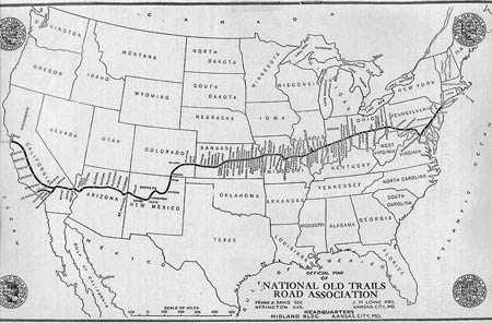
National Old Trails Road – Route 66
One of the first cross-country roads built in the USA was the National Old Trails Road. It spanned from Baltimore, Maryland to Los Angeles, with a branch reaching to San Francisco.
For the road’s alignment through the Cajon Pass, since John Brown’s road was still in use, just not as a toll road anymore, it was logical to use the same alignment as all of the road cuts were usable. However, from the mouth of Crowder Canyon to Summit Inn (the portion of the road covered in this tour), was one lane, narrow, steep and, in some places, next to precariously steep drop-offs. However, this didn’t scare the small amount of travelers in those days, since they didn’t have any organized roads before 1914.
When Route 66 was commissioned in 1926, much of the western-half of the National Old Trails Road alignment was used – from Los Angeles to New Mexico. But by 1918, the steep 18% grade proved to be too steep for the crude automobiles of those days and a new road was built that roughly follows the I-15 alignment. Much of the road alignments built after 1918 between the summit and where I-15 crosses the railroad tracks was obliterated when I-15 was built.
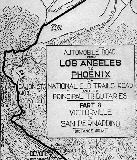
The following map from 1915 shows the road from Victorville to San Bernardino, including the Cajon Pass. It shows the two road alignments in the upper Cajon Pass. The road following this tour is the thin line below the number 27 and next to the word “Pass”.
Throughout the Cajon Pass between 1915 and 1950, the alignment of Route 66 changed frequently. In the case of the Brown Toll Road route, it proved to be too steep for the motor vehicles of the day and, with the increased traffic now that the cross-country road was built, the road needed to be widened to two lanes.
Other reasons for realignments of the road were because of washouts. Since the less-steep gradients for roads were next to natural drainages (creeks), sections of the roads were placed near these drainages. But it wasn’t discovered until a few years later that these seemingly harmless drainages would turn into rampaging rivers during the winter months, which caused the roads to be washed out. New alignments were often made when such a discovery was made. Much of this ended after the 1950 was constructed.
Railroad Tracks
Continuing our trip from the summit and through the road cut, the road descends steeply towards the railroad tracks. Our route crosses over four of them – two at-grade crossings and two underpasses.
The first crossing is at-grade. It crosses the only Union Pacific line. It was originally built by the Southern Pacific in 1968. This line was built as a bypass around busy Los Angeles, stretching between Colton and Palmdale.
Our road passes underneath the second and third lines, which are both BNSF. The second line is the youngest one of all – it was built in 2005. The third line, which is right next to the 2005 line, was built in 1915.
The fourth line is again an at-grade crossing. This line is the oldest of all four, as it was built in 1885 by the Atchison, Topeka and Santa Fe Railway (AT&SF). It formed the fourth Transcontinental railway across the United States. Today, because it is the steepest line, it is only used during periods of high train traffic, so the chances of encountering a train on this line is slim.
Past the fourth railroad crossing, the road is straight and less steep. Along this section, you might encounter faint traces of old pavement. This was pavement from when the road was upgraded from dirt in 1914 for the National Old Trails Road.
Hwy 138
Soon, the pavement of Hwy SR 138 is reached. Turn right. Today’s Hwy 138 was built on top of the old road alignment.
Just before Hwy 138 turns from 2 to 4 lanes, the old road veers off into the upper section of Crowder Canyon. There is no trace of where the old road was. However, our next stop will show plenty of evidence of the old road. Continue on Hwy 138 and turn left at the next street, which will pass by a McDonalds and a gas station.
Pacific Crest Trail
One of the best ways to experience the old road is to take a short hike along the famed Pacific Crest Trail (PCT). As shown in the virtual tour above, the PCT was built on top of the old road through Crowder Canyon. Along this half-mile stretch, you can see where an old bridge crossed the small creek in Crowder Canyon used to exist, as well as sections of old pavement that was laid down around 1915.
From where the McDonalds and gas station is located near Hwy 138 and I-15, continue down Wagon Wheel Road to its end, which is next to the freeway’s truck scales. Park your car by the historical monument and walk towards the end of the road. There, you’ll see several signs for the PCT.
Walk up the PCT which leads north into Crowder Canyon. After about a hundred feet, you will see two cement bridge abutments which used to hold the old bridge. From the south, the road came up along the northbound lanes of I-15 and then turned right into Crowder Canyon. Where it entered the canyon, the road crossed the creek and continued up the left side of the canyon, which is the path the PCT takes.
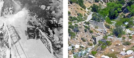
Continue your short hike past the site of the bridge. Soon you’ll be walking on top of the old chunks of pavement. You’ll also experience how the old road hugged the steep sides of Crowder Canyon. It will be difficult for anybody to imagine that a road built for automobiles used to pass through this narrow canyon.
The canyon is actually quite scenic as the freeway noise quickly fades as you pass the first turn. The trail is easy to follow and walk on. It makes several twists and turns for about a half mile. Along the way, you’ll see different segments of old pavement. It then opens up into a wide wash and, in the distance, you’ll see the large road cuts of I-15.
At this point, the PCT stops following the old road and turns right to climb a ridge. The old road’s alignment continued on the left (west) bank of the drainage until it reaches Highway 138 in another half mile.
Trip Map
Here is an original paved section of a Route 66 alignment built in 1918 and was used when 66 was commissioned in 1926.
Location of roadcut dug out in 1861 and beginning of the descent into the Cajon Pass.
Support Us
Help us fill up our tank with gas for our next trip by donating $5 and we’ll bring you back more quality virtual tours of our trips!
Your credit card payment is safe and easy using PayPal. Click the [Donate] button to get started:
Subscribe
See all our comprehensive virtual tour guides at:
![]()